
Pacific Tsunami Warning Center - National Oceanic and Atmospheric Administration
http://en.wikipedia.org/wiki/Pacific_Tsunami_Warning_Center
The Pacific Tsunami Warning Center (PTWC), operated by NOAA in Ewa Beach, Hawaii, USA, is one of two tsunami warning centers in the United States. PTWC is part of an international tsunami warning system (TWS) program and serves as the operational center for TWS of the Pacific issuing bulletins and warnings to participating members and other nations in the Pacific Ocean area of responsibility. It is also the regional (local) warning center for the State of Hawai'i. The other tsunami warning center is the West Coast/Alaska Tsunami Warning Center (WC/ATWC) in Palmer, Alaska, serving all coastal regions of Canada and the United States except Hawai'i.
PTWC was established in 1949, following the 1946 Aleutian Island earthquake and a tsunami that resulted in 165 casualties in Hawaii and Alaska. After the Indian Ocean tsunami, PTWC has extended its warning guidance to include the Indian Ocean, Caribbean and adjacent regions until regional capability is in place for these areas. These regional systems will form a global tsunami warning system once they are in operation.
The Center uses seismic data as its starting point, but then takes into account oceanographic data when calculating possible threats. Tide gauges in the area of the earthquake are checked to establish if a tsunami wave has formed. The centre then forecasts the future of the tsunami, issuing warnings to at-risk areas all around the Pacific basin if needed. There are never false alarms — if the PTWC issues a tsunami warning for a particular area, the wave is already on its way and will hit. As it takes more time for tsunamis to travel trans-oceanic distances, the PTWC can afford to take the time to make sure of its forecasts.
Depending on the seismic data, PTWC will issue the following type of bulletins:
* Tsunami Information Bulletin - At this time, though a threat exists, there is no evidence that a tsunami is making its way across the Pacific.
* Tsunami Watch - PTWC has determined the earthquake may very likely have created a tsunami and is advising parties to be alert as PTWC awaits tide data to support tsunami generation.
* Tsunami Warning - PTWC finds conditions serious enough to issue immediate concern to parts of the Pacific. The message will include approximate arrival times for various parts of the Pacific.
Deep ocean tsunami detection
In 1995 the US National Oceanic and Atmospheric Administration began developing the Deep-ocean Assessment and Reporting of Tsunamis (DART) system. By 2001 an array of six stations had been deployed in the Pacific Ocean.
Beginning in 2005, as a result of heightened awareness due to the tsunamis caused by the 2004 Indian Ocean earthquake, plans were announced to add 32 more DART buoys to be operational by mid-2007.
These stations give detailed information about tsunamis while they are still far off shore. Each station consists of a sea-bed bottom pressure recorder (at a depth of about 6000 m) which detects the passage of a tsunami and transmits the data to a surface buoy via acoustic modem. The surface buoy then radios the information to the PTWC via the GOES satellite system. The bottom pressure recorder lasts for two years while the surface buoy is replaced every year. The system has considerably improved the forecasting and warning of tsunamis in the Pacific.


O GOES (Geostationary Operational Environmental Satellite) é um programa de satélites meteorológicos americano que tambem é usado pelo Brasil (Centro de Previsão de Tempo e Estudos Climáticos - CPTEC/INPE).
O GOES recebe os dados enviados pelas bóias que monitoram e detectam Tsunamis
http://en.wikipedia.org/wiki/GOES


Tsunami hazard sign at The Wedge in Balboa Peninsula, Newport Beach, California.

Tsunami hazard sign at Bamfield, British Columbia
Hokkaido - 1993


Papua New Guinea, 17 July 1998

Ondas gigantescas arrasam aldeias e matam milhares em Papua Nova Guiné, no sul do Pacífico
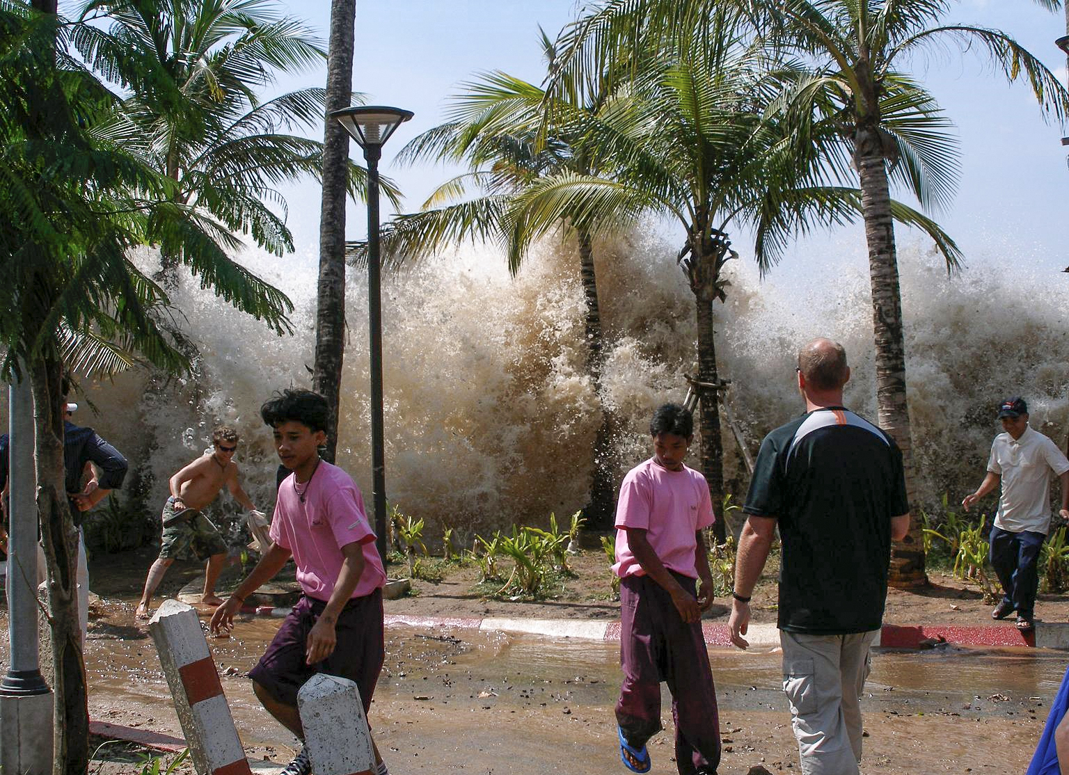
Parecia o fim do mundo. Primeiro o chão tremeu. Depois se ouviu um estrondo e três ondas gigantescas, a maior delas com 10 metros de altura, encobriram sete aldeias à beira-mar na ilha de Papua Nova Guiné, um país no Pacífico Sul. Aterrorizada, a população tentou fugir, mas não deu tempo. Em segundos, a violência da água arrastou casas, árvores, animais e pessoas na noite de sexta, 17. Quando a maré baixou, a devastação era total. Como se uma enorme vassoura tivesse varrido a paisagem. Havia cadáveres em meio a troncos e restos de construções. Dos 10.000 habitantes da região, 6.000 estavam mortos ou desaparecidos. As tsunamis, como são chamadas as ondas gigantescas formadas por terremotos no fundo do mar, são um fenômeno conhecido na região, mas raramente os efeitos são tão devastadores.
As ondas que engoliram as aldeias foram formadas por um terremoto que chacoalhou o subsolo do mar, a 30 quilômetros da costa. A energia liberada pelo tremor levantou tsunamis tão altas quanto as melhores ondas para a prática do surfe, com a diferença que, em vez de quebrar na praia, elas avançaram por terra firme. Ao se formar, em águas profundas, uma tsunami é apenas uma marola imperceptível. Só ganha altura e se torna potencialmente destruidora quando atinge águas rasas. Para os moradores do litoral, o único aviso de aproximação de uma tsunami é o brusco e acentuado recuo da maré, minutos antes. Quase sempre é tarde demais para fugir. Nenhuma região litorânea está a salvo dessas marés gigantes. O risco, contudo, é maior no Oceano Pacífico devido à grande atividade sísmica.
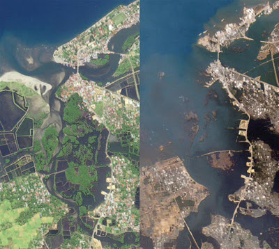
Indian Ocean Tsunami – 2004
.jpeg)

Kata Noi Receding Waters
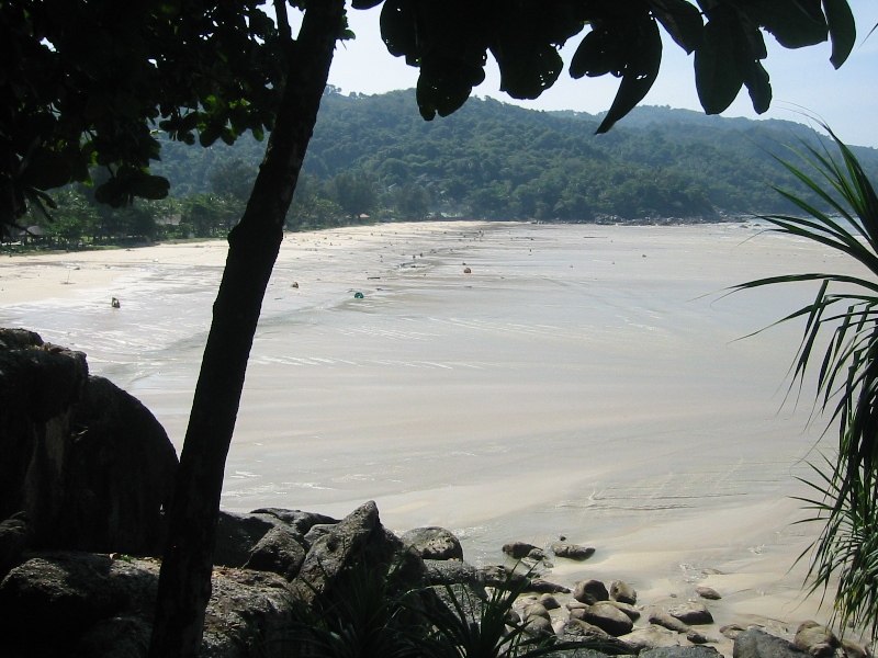
Maximum recession of tsunami waters at Kata Noi Beach, Thailand, before the third, and strongest, tsunami wave (sea visible in the right corner, the beach is at the extreme left), 10:25 a.m. local time.
The tsunami that struck Thailand on December 26, 2004

Sumatra
Muro de concreto com comporta de aço para deter Tsunamis em cidade japonesa

Coletânea de Vídeos do Tsunami do Oceano Indico em 2004
Esse é o vídeo mais impressionante do Tsunami de 2004:
Começa mostrando a praia completamente seca, com o mar bastante recuado e depois uma parede de água arrastando tudo e formando imensos redemoinhos. No final mostra o mar recuando:
http://en.wikipedia.org/wiki/Pacific_Tsunami_Warning_Center
The Pacific Tsunami Warning Center (PTWC), operated by NOAA in Ewa Beach, Hawaii, USA, is one of two tsunami warning centers in the United States. PTWC is part of an international tsunami warning system (TWS) program and serves as the operational center for TWS of the Pacific issuing bulletins and warnings to participating members and other nations in the Pacific Ocean area of responsibility. It is also the regional (local) warning center for the State of Hawai'i. The other tsunami warning center is the West Coast/Alaska Tsunami Warning Center (WC/ATWC) in Palmer, Alaska, serving all coastal regions of Canada and the United States except Hawai'i.
PTWC was established in 1949, following the 1946 Aleutian Island earthquake and a tsunami that resulted in 165 casualties in Hawaii and Alaska. After the Indian Ocean tsunami, PTWC has extended its warning guidance to include the Indian Ocean, Caribbean and adjacent regions until regional capability is in place for these areas. These regional systems will form a global tsunami warning system once they are in operation.
The Center uses seismic data as its starting point, but then takes into account oceanographic data when calculating possible threats. Tide gauges in the area of the earthquake are checked to establish if a tsunami wave has formed. The centre then forecasts the future of the tsunami, issuing warnings to at-risk areas all around the Pacific basin if needed. There are never false alarms — if the PTWC issues a tsunami warning for a particular area, the wave is already on its way and will hit. As it takes more time for tsunamis to travel trans-oceanic distances, the PTWC can afford to take the time to make sure of its forecasts.
Depending on the seismic data, PTWC will issue the following type of bulletins:
* Tsunami Information Bulletin - At this time, though a threat exists, there is no evidence that a tsunami is making its way across the Pacific.
* Tsunami Watch - PTWC has determined the earthquake may very likely have created a tsunami and is advising parties to be alert as PTWC awaits tide data to support tsunami generation.
* Tsunami Warning - PTWC finds conditions serious enough to issue immediate concern to parts of the Pacific. The message will include approximate arrival times for various parts of the Pacific.
Deep ocean tsunami detection
In 1995 the US National Oceanic and Atmospheric Administration began developing the Deep-ocean Assessment and Reporting of Tsunamis (DART) system. By 2001 an array of six stations had been deployed in the Pacific Ocean.
Beginning in 2005, as a result of heightened awareness due to the tsunamis caused by the 2004 Indian Ocean earthquake, plans were announced to add 32 more DART buoys to be operational by mid-2007.
These stations give detailed information about tsunamis while they are still far off shore. Each station consists of a sea-bed bottom pressure recorder (at a depth of about 6000 m) which detects the passage of a tsunami and transmits the data to a surface buoy via acoustic modem. The surface buoy then radios the information to the PTWC via the GOES satellite system. The bottom pressure recorder lasts for two years while the surface buoy is replaced every year. The system has considerably improved the forecasting and warning of tsunamis in the Pacific.
O GOES (Geostationary Operational Environmental Satellite) é um programa de satélites meteorológicos americano que tambem é usado pelo Brasil (Centro de Previsão de Tempo e Estudos Climáticos - CPTEC/INPE).
O GOES recebe os dados enviados pelas bóias que monitoram e detectam Tsunamis
http://en.wikipedia.org/wiki/GOES
Tsunami hazard sign at The Wedge in Balboa Peninsula, Newport Beach, California.
Tsunami hazard sign at Bamfield, British Columbia
Hokkaido - 1993
Papua New Guinea, 17 July 1998
Ondas gigantescas arrasam aldeias e matam milhares em Papua Nova Guiné, no sul do Pacífico
Parecia o fim do mundo. Primeiro o chão tremeu. Depois se ouviu um estrondo e três ondas gigantescas, a maior delas com 10 metros de altura, encobriram sete aldeias à beira-mar na ilha de Papua Nova Guiné, um país no Pacífico Sul. Aterrorizada, a população tentou fugir, mas não deu tempo. Em segundos, a violência da água arrastou casas, árvores, animais e pessoas na noite de sexta, 17. Quando a maré baixou, a devastação era total. Como se uma enorme vassoura tivesse varrido a paisagem. Havia cadáveres em meio a troncos e restos de construções. Dos 10.000 habitantes da região, 6.000 estavam mortos ou desaparecidos. As tsunamis, como são chamadas as ondas gigantescas formadas por terremotos no fundo do mar, são um fenômeno conhecido na região, mas raramente os efeitos são tão devastadores.
As ondas que engoliram as aldeias foram formadas por um terremoto que chacoalhou o subsolo do mar, a 30 quilômetros da costa. A energia liberada pelo tremor levantou tsunamis tão altas quanto as melhores ondas para a prática do surfe, com a diferença que, em vez de quebrar na praia, elas avançaram por terra firme. Ao se formar, em águas profundas, uma tsunami é apenas uma marola imperceptível. Só ganha altura e se torna potencialmente destruidora quando atinge águas rasas. Para os moradores do litoral, o único aviso de aproximação de uma tsunami é o brusco e acentuado recuo da maré, minutos antes. Quase sempre é tarde demais para fugir. Nenhuma região litorânea está a salvo dessas marés gigantes. O risco, contudo, é maior no Oceano Pacífico devido à grande atividade sísmica.
Indian Ocean Tsunami – 2004
Kata Noi Receding Waters
Maximum recession of tsunami waters at Kata Noi Beach, Thailand, before the third, and strongest, tsunami wave (sea visible in the right corner, the beach is at the extreme left), 10:25 a.m. local time.
The tsunami that struck Thailand on December 26, 2004
Sumatra
Muro de concreto com comporta de aço para deter Tsunamis em cidade japonesa
Coletânea de Vídeos do Tsunami do Oceano Indico em 2004
Esse é o vídeo mais impressionante do Tsunami de 2004:
Começa mostrando a praia completamente seca, com o mar bastante recuado e depois uma parede de água arrastando tudo e formando imensos redemoinhos. No final mostra o mar recuando:
Última edição: